
Hiking Acadia Mountain
Difficulty: Strenuous
Distance: 2.6 miles, round-trip
Hiking Time: 2 hours
Elevation Change: 581 feet
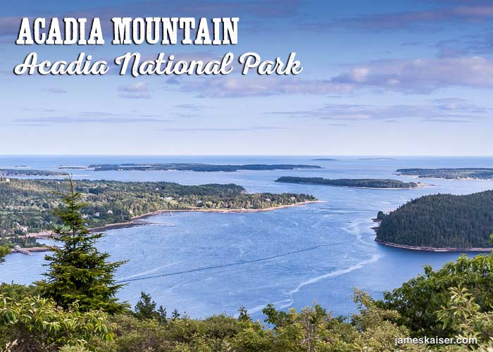
Acadia Mountain is my favorite hike on the west side of Mount Desert Island. Perched high above Somes Sound, it offers spectacular views of the East Coast’s loveliest fjard (not fjord) and the beautiful islands lying south.

Trailhead
The Acadia Mountain trail starts across the street from the Acadia Mountain parking area. The parking area is located off Route 102, about two miles north of Southwest Harbor. Parking is limited, particularly in the busy summer months. A better option is the free Island Explorer shuttle, which stops at Echo Lake on the Southwest Harbor route.
Local Tip!
After finishing the Acadia Mountain hike, there’s nothing better than cooling off in Echo Lake across from the trailhead. A short path through the woods leads to a granite ledge alongside Echo Lake. Be sure to bring your swimsuit and a towel.
Trail Description
From the trailhead, the Acadia Mountain Trail rises through a shady spruce-fir forest. You’ll soon reach Man O’ War Truck Road. Turn left on the wide dirt road, and soon you’ll reconnect with the Acadia Mountain Trail.
Continue through the forest until you reach a large granite ledge. This steep rock face requires a bit of scrambling. Fortunately, there are plenty of good footholds and handholds. This is arguably the hardest point on the trail, but it’s really not too hard.
Once past the ledge, continue through the forest to the top of Acadia Mountain. The summit rises 681 feet (208 meters) above Somes Sound. The view from the official peak is nice, but there’s an even better viewpoint a short distance farther.

Discover the best
of Acadia National Park

The bestselling Acadia guidebook for over two decades.
Just past the viewpoint, the trail drops nearly 600 feet in half a mile. The footing is good, but take your time and watch your step. Don’t rush. Be sure to enjoy the beautiful views on the way down.
Eventually, you’ll reach the base of Acadia Mountain. A short trail leads to Man ‘O War Brook Waterfall. This small cascade, which tumbles into Somes Sound, was an easy source of freshwater for 18th-century sailing ships. Because Somes Sound is so deep, ships could simply pull up alongside the waterfall to refill their water barrels.
Back on the trail, follow Man O’ War Brook Road back to the trailhead. The wide dirt road is easy to follow, with very little elevation change.
Extended Hiking Route
Strong hikers can connect Acadia Mountain with St. Sauveur Mountain, which offers more great views of Somes Sound. From St. Sauveur’s 679-foot (207-meter) peak, you can loop back to the Acadia Mountain Trailhead.
Acadia Mountain Hiking Photos

The Acadia Mountain Trail passes through the forest before heading uphill.
View from Acadia Mountain’s summit. To the left is Northeast Harbor. In the distance lie the Cranberry Isles.

You’ll find the best views just beyond Acadia Mountain’s summit. Spread out below are Somes Sound, flanked by Norumbega Mountain to the east and St. Sauveur to the west.

Summer boat parade, viewed from Acadia Mountain.

Man ‘O War Brook tumbles directly into Somes Sound. This small waterfall is a worthy detour after descending Acadia Mountain.
Discover the best
of Acadia National Park
The bestselling Acadia guidebook for over two decades.