Mount Desert Island is one of the most fascinating geologic features on the eastern seaboard. Unlike much of the East Coast, which is sandy and flat, Mount Desert Island towers 1,500 feet above a rocky shore.
No fewer than 26 mountain peaks rise above the island, some visible up to 60 miles at sea. How these mountains formed is a fascinating story that involves colliding continents, erupting volcanoes, scouring glaciers, and countless other splendid catastrophes.
The end result: one of the most beautiful islands in America.
Five hundred million years ago, Maine was covered by an ancient ocean that pre-dated the modern Atlantic. Geologists call this ocean the Iapetus Ocean (Iapetus was the father of Atlas, “Atlantic”).
As ancient rivers flowed into the Iapetus Ocean, vast amounts of sediment accumulated offshore. This sediment—a combination of sand, mud, and silt—piled up in thick layers, and over millions of years the bottom layers were compressed into sedimentary rock.
As tectonic plates shifted, this newly formed rock was pushed deep below the surface of the Earth where extreme heat and pressure transformed the sedimentary rock into schist, a metamorphic rock similar to slate. The schist that formed is called Ellsworth schist, and it is the oldest rock found on Mount Desert Island.
After the Ellsworth schist formed, tectonic action pushed it near the surface where it became the floor of the Iapetus Ocean.
As rivers from ancient continents deposited fresh sediments into the Iapetus Ocean around 420 million years ago, a new layer of sedimentary rocks formed on top of the Ellsworth schist. These new sedimentary rocks are called the Bar Harbor Formation.
Roughly 20 million years later, a string of volcanic islands formed in the Iapetus Ocean, and ash from erupting volcanoes settled on top of the Bar Harbor Formation, forming a third set of rocks: the Cranberry Isles Series.
By about 400 million years ago, the three oldest rocks on Mount Desert Island—Ellsworth schist, Bar Harbor Formation, and Cranberry Isles Series—had formed.
At this point all three rocks were part of an ancient continent called Avalonia, lying somewhere between North America and Europe in the Iapetus Ocean.
But slowly, as tectonic plates shifted, North America and Avalonia started moving toward each other, and eventually the two continents collided.
The collision pushed up a massive mountain chain and caused huge pools of magma to rise up under the previously formed Avalonian rocks. Around 360 million years ago, some of this magma cooled into granite, creating the fourth (and most famous) rock formation on Mount Desert Island. But at this point all four rocks were still buried deep underground.
Although geologists know a good deal about rock formation on Mount Desert Island between 500 and 350 million years ago, the last 350 million years are a bit of a mystery. Any evidence indicating what kind of landscape existed here has long since eroded away.
They do know, however, that after the collision of North America and Avalonia, Africa and Eurasia smashed into North America to form a huge supercontinent called Pangea. These collisions also pushed up the Appalachian Mountains. At this point Maine was located near the geographic center of Pangea—a position close to the Equator with a warm, tropical climate.
Then, around 200 million years ago, Pangea started to break apart. Around 150 million years ago, Avalonia split in two with the western portion stuck to North America and the eastern portion stuck to Europe. (Even today, coastal Maine and Western Europe share many of the same Avalonian rocks.)
As North America and Europe drifted apart, the Atlantic Ocean was born and North America moved north from the equator to its present location.
During this time, erosion slowly chipped away the landscape to reveal the rocks that would ultimately form Mount Desert Island. But it would take one last dramatic act of geology before the island took on the familiar profile we know today.
The Ice Age
Around two million years ago, Earth entered the Ice Age and thick layers of snow accumulated in the Arctic that compacted into massive sheets of ice.
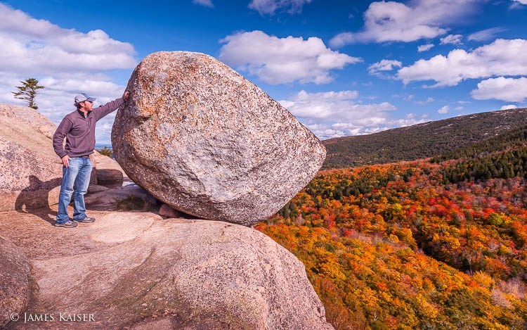
Soon the ice sheets were set into motion under the pressure of their own weight, at which point they became glaciers. Pushing south, the glaciers consumed everything in their path. Boulders, soil, trees—everything but the bedrock was picked up and carried along…
Continued in Acadia National Park: The Complete Guide
Discover the best
of Acadia National Park

The bestselling Acadia guidebook for over two decades.